Alpinisme / Mountaineering (1/2)

Spring & Summer 2000


Vue du ciel / From the sky !

Pour obtenir le nom des sommets, passez la souris sur la photo...
To get the name of the summits, leave the mouse on the picture and wait a little...


Suisse / Switzerland (Zermatt range)


Le long d'une l'arete dans la partie Suisse des Alpes. Un sommet a plus de 4000m dans les nuages.
Along a ridge in the Suiss part of the Alps. Altitude: 4000m. The summit will be in the snow and winds


La Meije / La Meije range


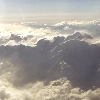
Couché de soleil a 3600m pres de la Meije. Mer de nuage.
Sunset at 3600m near La Meije. A nice cloud sea is below us.

Lever de soleil sur / Sunrise on
le Doigt de Dieu /
la MeijeOrientale.

Le doigt de Dieu

Sur la gauche, 50m sous le sommet. Nous arretons a 3930m, la neige recouvrant un peu trop le rocher.
On the left is a picture 50m below the summit. Almost easy to climb, the way cover with snow did not allow us to climb to the top. We stopped at 3930m.

La montée au doigt de Dieu a droite. Early in the morning, the ascent of Le Doigt de Dieu starts with red and yellow sunrise. The peak (almost 4000m) is the one fully visible on the right hand side. On the left of the picture is La Meije Orientale.

Sur la gauche, montée au doigt de Dieu avec la Meije Orientale.
On the way to Le doigt de Dieu. The peak on the right is the far est peak of La Meije range.

Vue vers la Meije.
The view toward the Meije (in the background) is fantastic. Here we are well above the surrounding peaks, this is where gods play with the elements.!


Glaciers of Le Tour, Trient, Saleina and Argentiere.


Nord /North face of l'aiguille d'Argentiere
'Les 3 Cols'

Un grand circuit effectué au printemps entre le refuge Albert 1er, le col du Tour, le glacier du Trient, la fenetre de Saleina puis le glacier avant de traverser le col du Chardonnet et redescendre le glacier d'Argentiere (12h).
A long way between Albert I hut to Argentiere going up to the high pass of Le Tour, then crossing Trient glacier, Salena glacier (where you can see the north face of l'aiguille d'Argentiere). Then you cross the sometimes steep and dangerous Chardonnet pass before going down to Argentiere glacier. A wild and long (12h) day walk in a glacier environement.

Glacier and aiguille d'Argentiere La Verte from Chardonnet pass.


La Vallée Blanche / The 'White Valley'


Descente a ski 3842m
Ski descent from 3842m


Panorama de l'aiguille du Midi. Chaque jour en hiver, des centaines de skieurs descendent l'arete et s'elancent sur une 'piste' de 10km sur les glaciers.
Cloudy panorama from l'aiguille du Midi. On the right handside is the exit of galleries coming from the Chamonix-aiguille du midi telepherique. The dangerous North East ridge is stepped down by hundreds of ski runners each day. After 100m, the slope becomes rather flat and the 10 km descent starts.


08-23-2001

Siou